Carolinas growth update: urban changes, rural losses

Where are urban regions growing – in their cores or suburbs? What is happening in rural areas? New population figures have fostered speculation about what growth in urban regions will be like in the future. For rural parts of the Carolinas, the issue isn’t about growth at all, but widespread decline in population.
The 2000s urban growth: center or fringe?
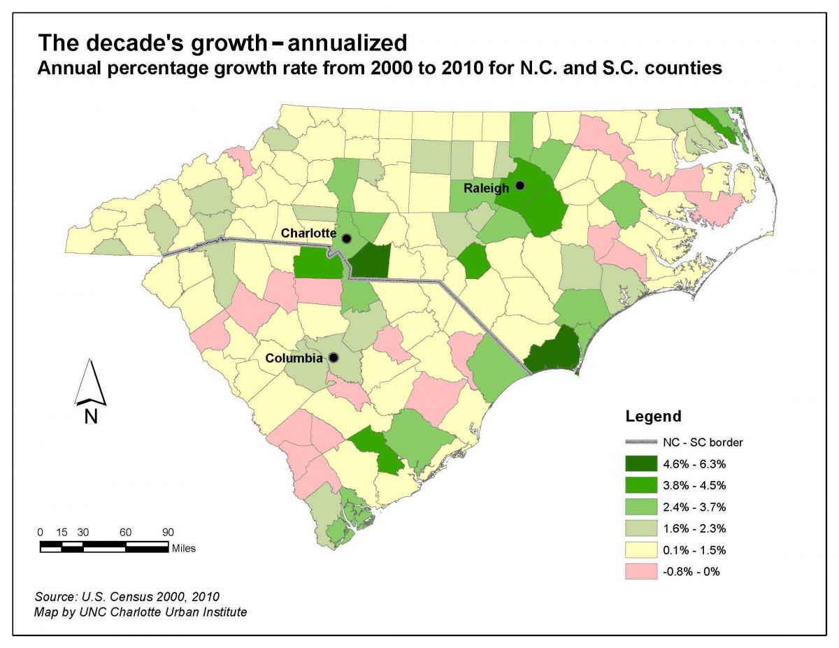
The map below takes counties’ population growth in both Carolinas through the 2000s and shows it as an annualized percent growth rate per year.* Charlotte’s urban region showed many characteristics of other large U.S. metros over the past decade. Much of the strongest population growth occurred in the suburban counties surrounding the core. Since Mecklenburg County (home to Charlotte) contained more undeveloped area in 2000 than many other large urban regions’ core counties, it also had strong growth within its boundaries. However, several adjacent counties outpaced the core county over the decade in growth rates. In the Charlotte region, Cabarrus, Union and York counties all exceeded Mecklenburg’s growth rate for the decade. The map also highlights how much North Carolina’s growth was focused on the Charlotte and Raleigh urban regions.

Raleigh, center of the second-largest urban area in the two states, does not quite fit the national trend of stronger suburban county growth during the decade, since so much development was within Wake County’s larger area. None of the larger S.C. cities experienced the kind of growth Charlotte and Raleigh’s regions saw between 2000 and 2010.
New trends: Focused growth, widespread losses
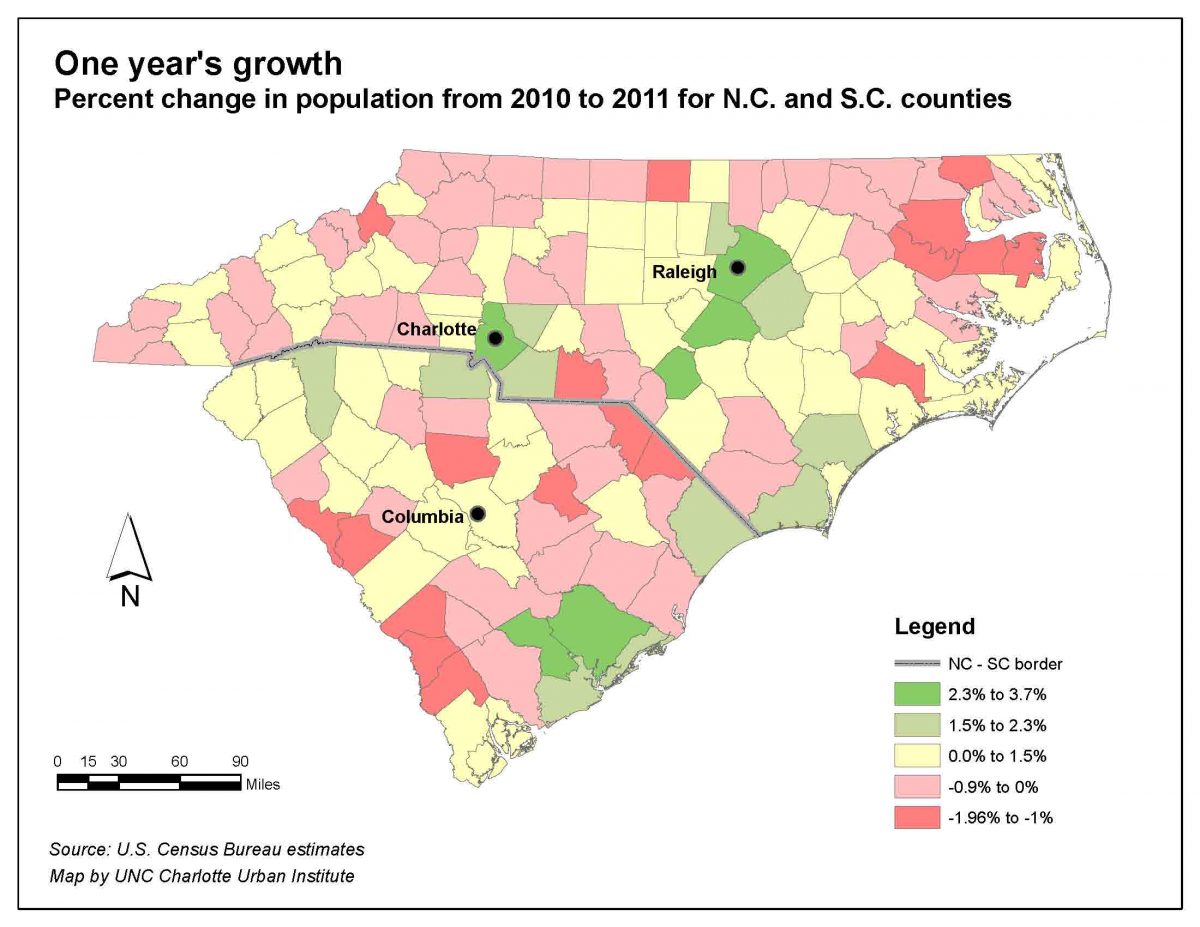
The Census Bureau’s estimate of the population growth from mid-2010 to mid-2011 is shown in the map below. These two maps were adjusted so that the colors representing the decade’s average change per year in the map above coincides with the one-year estimates in the map below, where possible, to improve the comparison. Notice that the core county of Charlotte’s region is the strongest in population growth, albeit at an overall slower pace than the region saw over the decade. This matches the national trend of the past year, in which many core urban counties are showing stronger growth compared to suburban counties.
In this trend, Raleigh does match up, with the rate in adjacent Johnston County (to Raleigh’s southeast) now noticeably slower than Wake County (Wake and Johnston were close in growth rates in the previous decade). The two counties south of Raleigh with similarly strong growth (Hoke and Harnett) have benefited from national programs to relocate military bases, which have caused growth at the huge Fort Bragg Army and Pope Air Force bases in Cumberland, Hoke and Harnett counties. S.C. counties north of Charleston have benefited from growth in a number of industries, including Boeing’s decision to bring production of its new model, the Dreamliner, to North Charleston.
| An interactive map is available of the latest estimates by clicking here. The map allows you to explore the data in more detail, including seeing the components of population growth for each county. You can also explore trends over time for Charlotte area counties on our Regional Indicators interactive graphs.(Note:Regional indicators data use different dates for calculations, so growth rates differ slightly.) |
While the Charlotte and Raleigh urban regions follow the trend of stronger growth in urban core counties than surrounding ones, the most striking thing in the second map is how many counties saw population decline. Overall, half of all S.C. counties and nearly half the N.C. counties are estimated to have lost population from July 2010 to July 2011. Even with this large number of counties estimated to have lost people, both states showed growth in total population, pointing to a continuing transition to a more urban and metropolitan population in both states
Measured over the previous decade, the first map makes clear that a few counties were in longer-term population decline, but the recent figures show estimated population losses across a wide portion of the two states – and almost exclusively in rural areas. Anson County, east of Charlotte but still in the Charlotte metro area, saw the strongest declines in that region: -1.13 percent from 2010 to 2011. McCormick County, S.C., on the Georgia line north of Augusta, Ga., had the largest decline in the two states: -1.96 percent. A wide swath of the S.C. coastal plain as well as northeast and western North Carolina also contains many counties that lost population.
 Bill Graves from the UNC Charlotte Department of Geography and Earth Science wonders if the numbers could represent the early stages of a population reshuffling nationwide. “I think the latest one-year estimates reflect an overall decline in migration due to the nationwide housing slump. And, the migration that is occurring is focused on urban rather than suburban environments. The combination of the subprime mortgage crisis and rising gas prices are severely impacting exurban communities. This is the first time in my memory that Mecklenburg outpaced the growth in Union, or that there was such a difference between Wake and Johnston’s growth.”
As for the rural and suburban areas, Graves said, “For the past 30 years, much of N.C.’s non-urban growth was driven by exurbanization – with lengthening commutes to work in cities. That’s less attractive in an era of $4-a-gallon gas, and some N.C. cities may have already reached the point that further exurban expansion is no longer necessary or attractive. The Triad may be at that point now, for instance.”
These early figures on the population changes occurring after the 2010 census have limitations. They are for a one-year period, so, how long these patterns will endure is a question. However, if this is the beginning of new trends of lower overall growth focused almost exclusively on cities, and reshuffling of populations out of large portions of rural Carolinas counties, it is not too early to begin examining the potential effects.
For a map of the one-year population changes with more detailed information about each county, click here.
Time-series data on Charlotte area counties on population as well as other items is available here. (Note data referenced in this article use a slightly different time period for growth calculations, so referenced growth rates are slightly different.)
*Population growth through the decade (2000 to 2010) is averaged to create a straight-line growth rate.
